Robert Stumm
The Insurance Map
An Indispensable Postcard Collecting Tool
Possibly nothing is more vexing or challenging than trying to identify buildings in a postcard streetscape or bird’s eye view. Sorting through a cluster of buildings and determining how they were used turns an ordinary postcard into a historical document. Unfortunately, unless the structure pictured has a readable advertising sign, or by some chance is still standing, discovering the usage seems a hopeless task. There is, however, a resource tool available to collectors which can instantly transform a novice detective into a supersleuth – that tool is a Sanborn Insurance map.
An insurance map is an elaborate plot map. Individual buildings within a commercial or residential district are portrayed at a scale of 50-feet to the inch and accompanied by very detailed information. The reason that insurance maps are such an unfamiliar tool, even to scholars, is that they have been used exclusively by fire insurance companies and underwriters.
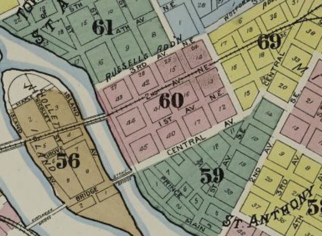
The district maps are identified by page number.
In this case we want “districts 56, 59 and 60.”
One interesting feature of a Sanborn Insurance Map was the color-coding of the buildings by construction material; if a building on a map is pink, it is constructed of brick, yellow is of frame (wood) construction, blue is stone. The illustration below is from Minneapolis, page 37.

Before proceeding, a bit of history on insurance maps might be helpful. British cartographers developed insurance maps in the late 18th century because insurance companies had to know as much as possible about the buildings they were insuring. The first such map produced in the United States was of Charleston, South Carolina, in 1790. Still a rural society at the time, there was little need for insurance maps, but when urban communities started sprouting up in the 1840s, a demand for these maps was created.
Initially, dozens of small regional companies turned out insurance maps. Soon, one by one, the small concerns were swallowed up by the Sanborn Map Company. Founded in 1866 by a young surveyor from Massachusetts name Daniel Alfred Sanborn, his company had by 1890, forged a monopoly. The Sanborn Company’s most prosperous years were in the 1920s when it had over 700 employees on its payroll.
Starting around 1950, insurance companies began supplanting their insurance maps with other, less expensive technologies, and today (1971, this article first appeared in the May 1971 Postcard Collector magazine. Sanborn produced its last map update in 1977.) the very few maps that Sanborn produces are used by urban planners. There are some 50,000 Sanborn maps available at the present time, a rich bounty that has been underutilized.
* * *
The methodology in using an insurance map can be best explained by recounting how I identified the buildings in this early view of the Minneapolis, Minnesota, riverfront.
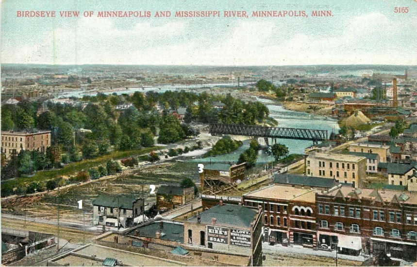
Estimating the card’s age by its 1906 postmark, I asked a librarian to find a 1905 insurance map. Intuition told me that the land mass in the left center of the view was Nicollet Island, so I looked first at the title sheet in the front of the volume to determine where I could find maps of this Mississippi River Island. The railroad bridge, which by the way is still standing (remember this was 1971, and in 2020 the bridge (somewhat modified) is still in use), enabled me to match up the view with the corresponding map. Thanks to the map key and the explicit information provided on each structure, including its construction material, the number of stories, dimensions and more, the rest was child’s play.
What I learned in this particular search was that the buildings lining the east-to-west street proved to be commercial dwellings. The partly revealed structure on Nicollet Island is the Eastman Flats, a prestigious apartment house in the beginning of the century. What makes this quest such a joy was the identity of the three frame structures positioned along the riverbank. The building on the left (#1) was a general store, next (#2) was a blacksmith shop, and the building on the right (#3) was a carriage shop. Only an insurance map allows us to identify temporary structures of this type.
To determine if an insurance map has ever been done on your city or town, consult the government publication Fire Insurance Maps in the Library of Congress. Sadly, this item may be out of print. If you are unable to locate a copy, visit https://www.loc.gov/collections/sanborn-maps.
If your search is successful and you learn that maps of your city were made, you are most likely to find them in local historical museums, college libraries, and at state and local historical societies that have large holdings.
One caution – like postcard collecting, rifling through these musty old maps can be addicting!
* * *
ATTENTION READERS: After reading this Postcard History lesson, if you use what you learned here to identify buildings on cards in your collection, please let us know your success in the comments section below or email your story to editor@postcardhistory.net.
Did the Sanborn maps only exist in the United States?
Similar maps were made in the United Kingdom but not by Sanborn. There is a good summary of the company’s history online at WikipediA.
I have used the Sanborn maps frequently in my research on the history of my hometown and found them very helpful. I originally got a set from my state archives. I have since purchased a set on a CD on ebay.The maps were not done every year and unfortunately the set I purchased was not in color. The business card that came with my set lists his business as (bad url), or email at oldmapman@gmail.com. He is located in Colorado.
I’m participating in a project to build a N scale model of what Rehoboth Beach, Delaware looked like in 1915, It is 70% finished. Finding a detailed insurance map showing the exact footprint and owner of every building has been a God-sent. Old postcards are also vital.
A Google search has informed me that Sanborn maps are available for both North Olmsted, Ohio (where I lived most of my life) and Lafayette, Indiana (where I currently reside). I’d love to own copies of those documents!