It should be stated that there is nothing official to verify my story because it has been fifty years since I hiked the Appalachian Trail for the first of three times. It was 1974 near the end of October, when in “a-year-off-from-college,” I found myself in the state of Tennessee walking north along the North Carolina state line.
That was when I bought this postcard. It was purchased in a tiny general store in Gatlinburg. I paid a dime for the card and mailed it to my mom and dad in Williamstown, Massachusetts, with an 8¢ stamp. This does not count in my collection. I’ll tell you why later.
I have no idea how many miles I have hiked on the trails in America, Canada, Scotland, Wales, England, and Chile in the last five decades but before I returned home from Maine (where the Appalachian Trail ends in Baxter State Park) I decided to try the Beehive Loop Trail in Acadia National Park.
Then one day the following spring when I had decided to do my best to bum around New England that summer, I came upon the Taconic Crest Trail. That day, like the one in Tennessee, I bought a postcard and slipped it down inside my backpack and I set off on a life changing experience. At the trailhead in Hancock, Massachusetts, which is but 15 miles down Route 7 from my parent’s home in Williamstown, I met two college girls who wanted to hike the Taconic before looking for summer employment but did not want to hike the trail alone. We talked for over two hours that afternoon and finally decided that the three of us would leave at daybreak the next morning.
Evelyn was as tall as Nancy was short, I think Evey was 5’ 11”, Nancy was 4’ 10”. Evey was a junior-year education major at Boston University; Nancy was a sophomore-year pre-everything major (undeclared but leaning to medical research) at Emmanuel College. After her graduation and a year in Kenya doing diabetes research, Nancy and I married in a small Boston suburb. This was our home until the fall of last year.
The card I bought that day in Hancock was the Large Letter postcard you see below.

The Taconic Trail is the name the locals use, but the official name is the Taconic Crest Trail. This 35-miles-long New York, Massachusetts, and Vermont landmark trail is one that follows the ridgeline of the Taconic Mountains. The trail is maintained by the Taconic Hiking Club and the conservation bureaus in New York and Massachusetts. The trail runs north and south along the state lines and the hiker who manages the entire 35 miles crosses that line in seven locations.
It was in the 1940s when the trail received its first official sanction from the New York Department of Recreation, however it wasn’t mapped as an official trail until the 1970s when a group of volunteers from the Berkshire Chapter of the Appalachian Mountain Hiking Club completed the task.
Over the years, the Taconic (the name is likely a derivative from the Algonquian word for trees or forest) has been improved and expanded by several groups that have created eight branch trails, installed trail-head markers, trail mile markers, and several shelters. The trail passes through a diverse range of landscapes and is very popular with amateur as well as experienced hikers because of the abundant chances of seeing wildlife and finding rare plant species.
Parts of the Taconic Trail pass through areas that were once home to Native American tribes, and also uses pathways of early European settlers who used the ridgeline as a way to reach northern destinations without river interference.
Not much more than a couple stone tosses from the Taconic Mountains are the western New England cities of Pittsfield, Massachusetts and Benington, Vermont. When you tire of hiking there are dozens of cultural, culinary, and epicurean experiences available.
Nancy and I hiked the Taconic one other time in 1989.

The Tamiami Trail is not a hiking trail; it’s a highway known as U.S. Route 41. This historic roadway stretches across the southern part of Florida, connecting Tampa on the west coast to Miami on the east coast.
The trail was originally conceived in the early 20th century as a way to improve transportation and access to the remote and undeveloped areas of the southern part of the state.
Construction on the Tamiami Trail began in 1915 and was completed in 1928, making it one of the first major roads to traverse the Florida Everglades. The project was a massive undertaking, with thousands of workers laboring to build the road through the swamps, marshes, and wilderness of the Everglades. The trail was named after the cities it connected – Tampa and Miami.
The Tamiami Trail is a popular scenic route and is the easiest way to visit the Everglades National Park.
Nancy and I crossed the Tamiami in 1990. She drove half the distance to Tampa while I took pictures from the passenger’s seat, then after a while we switched places. We didn’t walk an inch except when we stopped for lunch.

In the spring of 1992, I was doing Civil War research and found an obscure reference to a hiking trail named after a Civil War regiment from Pennsylvania called The Bucktails. They were sharpshooters who fought throughout the war as a volunteer infantry regiment in the Union Army. The Bucktails saw action at Antietam, Fredericksburg, and Gettysburg.
We made reservations to hike the trail in April but Nancy got an emergency call for a chicken pox research project in Chicago, so we took the long way around the Great Lakes to Chicago. I dropped her off at the University of Chicago Research Center and headed for the Bucktail Trail alone. I hiked the 38 miles north on a Monday and Tuesday, rested for one day and returned to the southern trailehead by Friday at noon.
The trail information we received with our reservation confirmation was very accurate. The trail is known for its rugged terrain and picturesque views. I really don’t like to hike alone, but on this occasion, I was happy that Nancy was safely at work helping children.
The Bucktail Trail was initially created in the 1920s by the Civilian Conservation Corps (CCC), a New Deal program that aimed to provide employment for young men during the Great Depression. The CCC focused on building recreational facilities and improving natural resources, and the Bucktail Trail was one of their many projects.
Over the years, the trail has been improved, but shortened to 34 miles. It now connects to other trails in the Susquehannock State Forest, offering hikers quite a challenge.

The Mohawk Trail is among the oldest and most historic byways in the United States. Originally used by Native American tribes, such as the Mohicans and Mohawks, the trail was a vital trade route that connected the Hudson River Valley to the Connecticut River Valley.
In the late 1600s, the early English settlers began to use the remnants of the Native American trail for trade and travel between the colonies of Massachusetts and New York. The trail became an important link between the coastal settlements. The trail also served as a military route during the French and Indian War and the American Revolution.
In 1914, the Mohawk Trail Association was formed to promote the use of the trail as a recreational hiking route. The association worked to improve the road and added many amenities for travelers.
Nancy and I only hiked the Mohawk once. It was just a bit too long for Nancy. At over 60 miles it is mostly an east to west experience through western Massachusetts. It passes through several towns and lush forests, and remains a popular destination for hikers and cyclists.
***
Before I return to the card I purchased in Gatlinburg, Tennessee, let me tell you about the cards above. These are the only four Large Letter postcards I have found. They are my whole collection of Trail postcards.
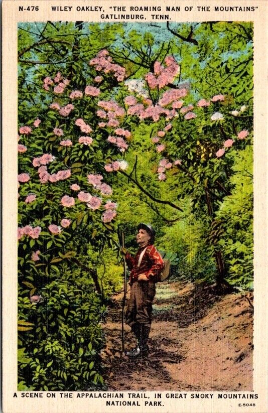
The Gatlinburg card shows a spot along the Appalachian Trail where a man named Wilie Oakley is admiring a flowering tree. Mr. Oakley died in 1954, twenty years before I was in Gatlinburg, but on the day that I arrived the townsfolk were preparing a “remembrance” day in his honor. As the years have come and gone, I have attempted to learn about Oakley and he, without knowing, has set a fine example of hiking etiquette and outdoorsmanship. Today as I remember my Nancy, I realize that those two people have helped me be a better person in many ways.
***
If you have a story of hiking a trail, I’m sure every Postcard
History subscriber would like to read it.
What a sweet article! I have driven the Mohawk Trail when it was ablaze in the autumn colors. And the Tamiami Trail is a fascinating story to read about. Amazing hardships building it! Love the birds down that way. Articles like this are a stress relief from a world spinning out of control. Thanks for sharing it!
Thank you for the information on the Mohawk trail. I have several ( 6to10) postcards that feature various segments of the Mohawk trail and the few New Englanders I have met knew nothing about it. So glad to read of it.
I went to college with the son of Ed Garvey, the author of the book Appalachian Hiker: Adventure of a Lifetime.
This is a great article. I was especially interested in seeing the picture of Wiley Oakley. I have hiked in this area but have never seen this post card, so I will seek it out. Another great U.S. hiking trail is Longs Trail in Vermont, (starts north of the Mohawk Trail) and there are lots of post cards of various segments of it; part of it coincides with the AT. Two of my favorite European trails are in the Alps: Tour du Mont Blanc and the Haute (High) Route. There are many post cards of these two spectacular routes, even… Read more »